Ilkley Moor
An area full of interest
including many carved rocks and several stone circles easily accessible
from Leeds and Bradford by car train or bus. Back
to Yorkshire Dales Contents Page ![]()
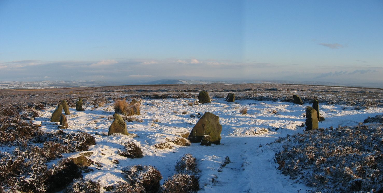 |
| 12 Apostles stone circle |
Map reading is essential for this walk. The relevant map is OS Explorer 27 Lower Wharfedale

Walk - Menston to Ilkley - 9 miles - 5 hours - by train/bus or 7 mile circular from Menston- Start at Menston Railway Station and proceed along the alleyway (at rear of station) and bear right to follow the unmetalled road parallel to the railway track. At he end bear right onto Burley Old Lane. Just before the railway bridge (as the road swings to the right) carry straight on down Clarence Drive, a private road. At the end of the road pass through a gate onto an enclosed footpath. After the stile and immediately turn left. The path soon meets Carr Beck. Cross the Beck on a small footbridge and follow the right hand bank through 2 gates and 3 gap stiles to reach Bleach Mill. After the last gap stile carry straight across the junction of paths to quickly ascend the wooded ravine passing over 2 gap stiles and past the old bleaching ponds. After a final stile the path crosses the stream to emerge between the two houses and continue up the steep private driveway. At the top of the drive cross the moor road and continue up Green Lane, a largely unmetalled track serving various cottages and farms, for approx ˝ mile until a gate is reached at the edge of the moor.
Passing through the gate bear north east near the telegraph pole and look for a feint path proceeding up the open moorland and to the right of Carr Bottom Reservoir. This becomes more obvious and eventually arrives at a junction with a more obvious path. Turn left and follow the path uphill passing Lower Lanshaw Reservoir and continuing to a rocky outcrop on the skyline. A shooting cabin will come into view. Hawksworth Moor Circle is located in the heather about 50m due south from the hut
 |
|
Hawksworth Moor Circle Grid ref 136446 - note proximity to shooting cabin - the snow helps to illustrate the circle |
Now follow the well used footpath due west across open moorland to the high point on the horizon ignoring the right hand fork to Upper Lanshaw Reservoir dam on the right hand side. After approx ˝ mile a junction with the Ilkley-Bingley path should be reached. Turn right and proceed for 100m passing The Twelve Apostles stone circle is on the right hand side. Continue for a further 50m or so until a boundary stone at Lanshaw Lad is reached.
 |
|
Twelve
Apostles- the precise reason is not known but this is the most visited
of four circles on the moor
|
Turn left and again following a westerly course follow the path to the trig point ignoring a branch off to the right. On reaching the trig point [402m] continue on the same course soon following a wall on to a recently flagged path to Whetstone Gate. Notice along the way one of the Stanza Stones with a poem by Simon Armitage. Cross the vehicle track at Whetstone Gate and maintaining the top of the hill follow the wall for 800m to West Buck Stones. Now follow the edge of a plantation for 400m or so and after a slight change in direction of the plantation boundary cross a stile and continue to the trig point at Long Ridge End [384m]. Double back on a the slightly lower path towards Ilkley passing over a stile. This continues at this level to meet the minor road and track to Whetstone Gate down into Ilkley.
However a preferable option is to drop down to the lower path just before a rocky outcrop to Pipers Crag (no obvious path) and then turn right onto a well-used path towards Ilkley know as Panorama Walk. After 500m the path passes Swastika Stone behind railings on the left. Continuing onwards at the small stream there is an option to turn left through a gateway down Hebers Ghyll a Victorian creation with footpaths a bridges weaving its way down the ghyll to emerge at what will become Grove Road at the bottom. Follow this into Ilkley. Alternatively follow the path along the edge of the moor until meeting the minor road from Whetsone Gate. Then turn left downhill into the town centre.
.jpg) |
.jpg) |
| Grub Stones | Long End Ridge - Addingham High Moor |
.jpg) |
.jpg) |
| Across to Addingham | Swastika Stone and Panorama Walk |
Alternatively this can be turned into a circuit by carrying on downhill from Twelve Apostles and on reaching Gill Head cross two small steams. Turn right immediately after the second stream and follow the path downhill for 200m. Turn right at the bottom to cross the stream [might be difficult to spot] and the path rises up hill slightly to emerge in the former Bronze Age settlement with the house and enclose easily visible.
.JPG) |
| Bronze Age hut circle and enclosure at Green Slack |
Then pick up the vehicle track where the track turns to drop down the hillside carry straight on along the contour back towards Burley Woodhead soon following the edge of the moor. Drop down the path alongside the ravine above Burley Woodhead to meet the road. Turn right for a short while and then bear left at footpath sign pointing down private drive. This now proceeds directly to Menston crossing several fields and drive ways and after passing Hag Farm regain Bleach Mill Lane and thence into Menston.
Proceed to the station and get the train back to Menston and beyond. NB Trains run at 15-20min frequency weekdays and Saturday and hourly on Sunday
 |
 |
| Carved Rock Grid ref 126463 |
Swastika Stone - this is located at the end on Panorama Walk above Ilkley |
.JPG) |
.jpg) |
| Cup and ring marking on Haystack Rock SE 13188 46477 | Idol Stone on Green Slack SE 13345 45870 |
References: Prehistoric Rock Art Of The West Riding - published by English Heritage and the West Yorkshire Archeological Service - this gives details of locations and descriptions together with many photographs. The use of a GPS is recommended to assist in tracking the approximate locations - but this sometimes requires perseverance! Some are difficult to spot or obscure by undergrowth
Travel: www.northernrailway.co.uk-frequent
rail services from Leeds and Bradford to Ilkley and Menston. For bus services
see www.dalesbus.co.uk![]()
Important note:- Whilst the author has taken every care in assembling the information on this site, no responsibility can be accepted for any error or omission herein. If in any doubt walkers should consult the relevant OS map. All timings are approximate and for a person of average fitness and ability.
This page was last updated on 25-Dec-2024
Back to Yorkshire Dales Contents Page
Settle and Malham Ribblehead Garsdale Station (Upper Wensleydale) Dentdale and Howgills Wensleydale Kirkby Stephen Swaledale Upper Wharfedale Lower Wharfedale Nidderdale Ilkley Moor Washburn Valley
©John Carey 2009