An area of outstanding scenery with a steep sided valley, rock formations and remote moorland not as often frequented by walkers than the other dales. There are various starting points the main ones being Pateley Bridge, Middlesmoor or Scar House. See also Nidd Valley Light Railway. Please click here to send a comment!

Map reading is essential for these walks. The relevant maps are Outdoor Leisure 30 Northern & Central areas (double sided) and the Nidderdale Explorer map
Travel:
There is a good bus service from Harrogate to Pateley Bridge on weekdays
[No 24] , but only a limited service in Upper Nidderdale. The Nidderdale
Rambler bus service operates on summer Sundays and once a month in Winter
from Pateley Bridge to Scar House and Middlesmoor - see www.dalesbus.org
for details
- Walk 1 - Middlesmoor - Scar House Circular - 9 miles
- Walk 2 - Pateley Circular - 11 miles
- Walk 3 - Little Whernside circular - 8 miles
- Walk 4 - Pateley Bridge and Yorkes Folly - 5 miles - a family walk
- Walk 5 - Brimham Rocks - 4 miles - a family walk
- Walk 6 - Scar House and Angram Circular 6.5 miles
- Back to Yorkshire Dales Contents Page
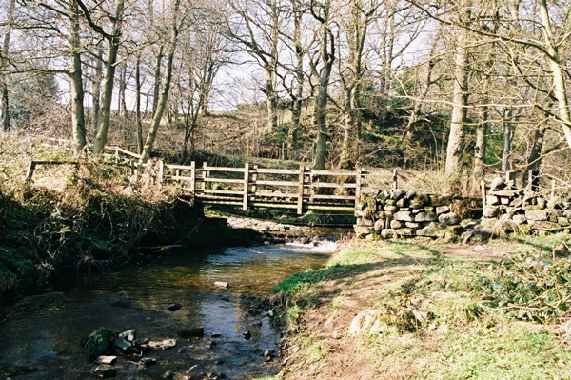
Walk 1 - Middlesmoor - Scar House Circular - 9 miles- Good views of Upper Nidderdale- Park in Middlesmoor car park and proceed up track to Scar House dam (2Ẅ Miles)- cross dam- bear left on other side and then sharp right after 200 yds - follow track up hill- maintain same contour with abrupt crossing of Woo Gill and passing shooting house- continue along track for 3Ẅ miles until further shooting house reached- drop steeply down hillside from shooting house towards farm- through farm yard and along farm road to meet vehicle road on other side of river - turn left and walk along road for ỳ mile- take footpath on right passing diagonally through fields and back to Middlesmoor and the Crown. Back to top
-
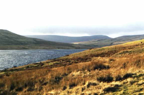
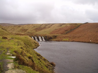
Scar House Reservoir and Great Whernside in distance / Dale Edge track follows the contour above the valley

-
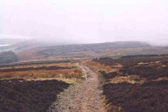
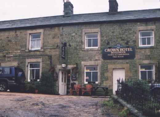
Dale Edge track near the shooting hut - the path drops steeply down the hillside here / The Crown at Middlesmoor
Walk 2 Pateley Circular -11 miles - An excellent circuit taking in Yorkes Folly, Guisecliff, the Nidd, the Fellbeck ravine, Brimham Rocks and finally panoramic views on the return to Pateley - a good day out!
Start from Pateley Showground turning left and then left along road to Bewerley. Then take 2nd right and after a 100m branch right (near a farm entrance) and follow zigzag path up through woods - cross road at top to Yorkes folly- follow cliffs to transmitter - cross stile and proceed down hill with wall on the right. Follow distinct grassy track into small valley and up the other side to pass through gate (unmarked). Pass through fields and a gate in the bottom of the valley proceeding in a straight line towards Harewell Hall farm. Go through farmyard (between buildings) and just beyond farm house there is a gate. From here it will be possible to see a footbridge across the river Nidd.

Cross River Nidd on footbridge and immediately bear right along river bank and then left up to main road at Low Laithe. Cross main road and proceed up track to Smelt Houses. Bear left for 50m across bridge and then right to side of house. The path now enters the confines of Fell Beck with its attractive waterfalls. Follow the path and after crossing footbridge there is a sharp right turn up a hillside and then left proceeding through the woods at higher level. After 1/2 mile the path goes through some slightly thicker bushes at the other side of which turn right (in front of house). After house this becomes a farm track now heading for the foot of Brimham Rocks. When the rocks come into view it should be possible to leave the track and freelance uphill through the many paths meandering through the rocks. At the top bear left towards Brimham House and keep to left of house passing Bear Rock. Keep to this path for 1/4 mile as it descends into small valley. Look for gap in wall on the left and parallel farm track below.
-
View towards Brimham House
Join farm track (almost doing a U turn) and proceed to High North Pasture farm. After farm the track bears right but the path goes diagonally across a well manicured field to reach a stile at the far side. Crossing stile proceed downhill through several fields with hedge on right to reach ford and foot bridge over Fell Beck. Cross footbridge onto track and then through two paddocks to top of hill on other side emerging at the left hand side of a house. Turn immediately left follow walled path clearly marked as the 'Nidderdale Way'. This meets a minor road - turn right uphill for 200m and then left. Follow this track passing houses until another minor is reached at Blazefield. Turn left downhill for 200m and then right on walled track which quickly emerges at the hamlet of Knott and then the metalled Panorama Walk back to Pateley passing Crown Hotel on the Main Street. Back to top
Walk 3 Little Whernside circular - 8 miles - Start from Yorkshire Water Authority car park at Scar House. Cross Scar House Dam and on other side bear left slightly follow track up hill and then follows side of reservoir for ẅ mile until site of old lodge is reached. 200m past lodge tun left at 'T' junction and then immediately right. The path follows almost a straight course to crest of the hill between Little Whernside and Great Whernside (can be boggy in places). After two miles crest is reached. Turn sharp right along crest of hill to reach top of Little Whernside. There are many peat bogs to be negotiated and so it is best not to do this one after wet weather.

-
Little Whernside from 'Dead Man's Hill' path near Scar house / Angram Reservoir with Great Whernside in Background - a bleak spot!
Once the peat bogs are cleared the views of the reservoirs are good and also there is a good view into Coverdale. Proceed down the hill to meet track from Coverdale. Turn Right downhill. At bottom (near lodge) carry straight on through two stiles and then either bear right to Angram Dam and return by road on far side or drop down to old tramway track on shore of reservoir and proceed back to Scar House Back to top

- Little Whernside from Angram Dam / Scar House Reservoir from Angram Dam
Walk 4 - Pateley Bridge and Yorkes Folly - 5 miles - an excellent family walk with a few sights along the way including Yorkes Folly and Guise Cliff.
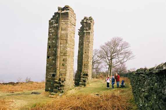
-
Yorkes Folly
Park in the showground carpark in Pateley Bridge and turn left along main road (out of Pateley). After a short distance turn left and walk through the small village of Bewerley. Take the 2nd turn right out of Bewerley and after 300m look for footpath sign at entrance to Strikes Farm. The footpath follows the beck for a short while before entering woodland. After passing buildings bear left and uphill through the woodland (do not go down to the footbridge). The path turns a few times before emerging at the boundary of the moorland. Passing through the gate walk onwards to cross the road at which point Yorkes Folly will be seen in distance.
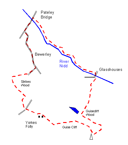
Passing Yorkes Folly, cross stile and follow path over top of Guisecliff with spectacular views across Nidderdale. Take care to avoid cliff edge and crevasses which will appear later. After passing the transmitter turn left down the hillside and then left again. The path enters woodland and follows the same contour for a while below the cliff. After a while the path emerges at a small lake. Bear right at this point the path again drops down the hillside (towards Glasshouses) emerging at a small hamlet. Follow the track to Glasshouses. Cross River Nidd by the road bridge and then turn immediately left to follow river bank all the way back to Pateley Bridge. Back to top
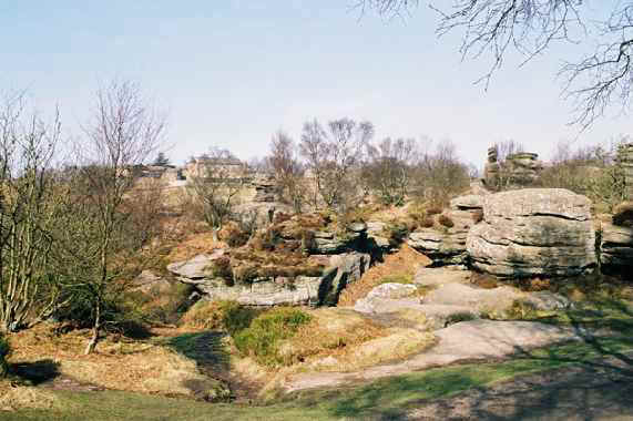
Walk 5 - Brimham Rocks - 4 miles - an excellent short family walk with a variety of scenery starting from the National Trust carpark at Brimham Rocks. From the carpark walk through the rocks towards the visitor centre passing to the the left hand side.

-
Rock formations carved by water / The stream going down to Smelthouses
The path continues to the rear of the rocks and follows the cliff edge before dropping into a small dip. After 400m a track will be seen running parallel at a slightly lower level. Cross over to the track and go downhill (effectively in opposite direction) to reach farmhouse. After farm house look for clearly marked stile diagonally across field. Cross stile and go downhill through several fields to meet beck.

At Mill House ford and footbridge (do not cross) bear left to walk along left hand bank of stream. This is clearly marked through woods. After a short while there is a staggered junction but the path effectively goes straight on dropping downhill very slightly. After 1/2 mile the path does almost a U turn and drops quickly to meet stream again. Cross footbridge and continue down to Smelthouses. Turn left at road for 400m and then left again along farm track. This veers right after last cottage and then continues uphill in a straight line for 1 mile to meet the road at the top. Turn left and then left again to return to Brimham Rocks carpark. Back to top
Walk 6 Scar House and Angram Circular 7m- A good circuit recently introduced by Yorkshire Water - Start at Scar House car park and cross dam following the shore line. Shortly after the shelter (half way along the reservoir) turn right up the hillside. At the top turn left and follow track to Angram Dam. The path around Angram is clearly defined with footbridges across the various inlets. Return from Angram along tarmacadam road. Back to top

Scar House Dam / Inlet to Angram Reservoir
Bus/ train services
- Service 24 runs Harrogate to Pateley Bridge every day
- DalesBus service 825 runs Harrogate - Pateley Bridge- Scar House / Middlesmoor slected Sundays in Winter
- DalesBus service 75 runs Harrogate - Skipton via Blubberhouses on Saturdays
- Northern Rail run regular trains services to Harrogate
See www.dalesbus.org for further information
Important note:- Whilst the author has taken every care in assembling the information on this site, no responsibility can be accepted for any error or omission herein. If in any doubt walkers should consult the relevant OS map.
Links
www.yorkshirewater.co.uk An excellent site with recreation section covering the water authority sites in Nidderdale and the Washburn
www.nidderdaleinfo.co.uk A local information site
This page was last updated on 20-Dec-2014
Back to Yorkshire Dales Contents Page
Upper Wharfedale Lower Wharfedale Ribblehead Nidderdale Malhamdale Middleton Fells Swaledale Ilkley Moor Washburn Valley Coverdale Moorcock Wensleydale Dentdale
©John Carey 2009